| | Robert Elsie | AL Art | AL History | AL Language | AL Literature | AL Photography | Contact | |
Robert Elsie
Texts and Documents of Albanian History
BACK | AL History

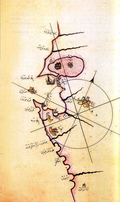
Piri Re'is map of the
coast of Vlora.
1521
Piri Re'is:
'Bahriye', a Sailor's HandbookPiri Re'is was a noted navigator in the service of the Sublime Porte. In Egypt he was appointed Admiral of the Fleet and took part in several expeditions to the Indian Ocean, until he was decapitated at the behest of the Ottoman authorities at some point before 1554. His major work, the 'Bahriye', is a sort of sailor's handbook complete with maps which he dedicated to Sultan Selim I in 1521 and subsequently to Sultan Suleyman the Magnificent in 1525. The 'Bahriye', composed in 130 chapters, provides a nautical description of all the Mediterranean coastline, including Albania (chapters 55, 56).
This chapter describes the Roumelian coast of Chimara (Himara) up to Avlona (Vlora). Accordingly, we shall endeavour first to describe the coast of Himara, beginning beyond the Cape of Himara, and then the coast from Vlora to Drac (Durrës). What we call Himara is situated on a lofty hill two miles inland from the sea. It is a castle belonging to the Sanjak of Janina. To the west of this castle there flows a large river which has water in both summer and winter. To the east, there is a harbour called Punar (1), which many people call the 'Harbour of the Hare'. It is a small port. Twenty five miles from here in the direction of Vlora is the island of Sazana (Sazan). Drinking water and a place to put ashore are to be found on the eastern side. On the island are the ruins of a church. You attach the ship's rope to the land here in front and drop anchor towards the east with the water at a depth of ten fathoms. If you cast anchor at a lesser depth, the floor of the sea will be rocky. There is also a rock in the water in the form of a threshing floor. it cannot be seen and is covered by seven fathoms of water. Opposite the island is the Albanian coast of Karaburun at a distance of four miles. It is eighteen miles from Vlora. Vlora is a well known settlement. The site best suited for landing a ship is as follows. In front of Vlora, there is a low and narrow spit of land at water level with shoals. They must be kept to the northwest and you must cast anchor on both sides because of the shoals. The ship must not approach the coastline. Only small vessels can sail into the narrow entrance (of the lagoon) and moor at the village. The interior of the lagoon is a large lake full of fish. Six miles from here, to the southeast of Vlora, there is a large course of water called Iring Suyu. This river is so big that when Venetian galleys tank water there, many of the soldiers can avail themselves of stores of drinking water, too. At the end of the bay in this body of water is a sandbank called Vaskalon (Orikum). Eighteen miles to the northwest of Vlora, there is a river called the Viyusa (Vjosa). Ships can sail into it. At times, however, the river deposits sand in its estuary, and then, galleys cannot enter it. As soon as the mouth of the river is open, any ship can sail in. From here to Durrës there are other well known waterways aside from the one just referred to. Of these, we shall only mention those of significance to navigators because there are shoals along the whole coast. It is ninety miles northwards from the island of Sazan to Durrës. The rest is noted on the map, so that not all the details need to be mentioned here. Map of Vlora with the Castle of Durrës.
This chapter describes the coast of Durrës. Durrës is a fortress situated on the coast. There is a sandbank in front of the fortress. Anyone wanting to conquer it with large ships would need an experienced pilot to reach the fortress so as not to run aground in the shoals. Once you get there, you must cast anchor on both sides because it is necessary to keep clear of the coast. The only way to put ashore with a large ship would be to proceed from the south, taking soundings along the coast which is to the east, and put ashore so that the low land spit remains to the northwest. Once the land spit is to the northwest, you must drop anchor right away. This is a good place for mooring. If you are sailing from Dubrovnik to Durrës, the Durrës shoals lie in a southwest to northeastly direction. Three miles to the northeast of these shoals is a harbour called Porto Palo, i.e. the 'Harbour of Piles'. At the end of the golf situated to the northeast of this harbour is a river called the Bojana (Buna), which flows past Arnaud Iskenderiyesi (Shkodra) into the sea. It is so large that ships can sail into its lower course. To the northwest of this river on the coast is a castle called Dulcigno (Ulcinj). This castle belongs to Venice. To the northwest of this castle on the coast, there is a castle called Antibar (Bar). To the west of this castle, there is a little island. There is a harbour in which you can moor with anchor and rope towards the island. It should be noted that this site holds anchors very well. The landmark of this castle, seen from the sea, is the high mountain rising above it. You must take course in the direction of this mountain in order to get to the castle. Twenty miles west of this castle lies the castle of Budua (Budva). Across from Budva there is an island which large ships can call at by the western entrance. You cast anchor in the middle between the island and the coast and tie the rope in the direction demanded by the wind, i.e. against it. Thereafter comes Kotor, a castle situated up on a high hill at the end of a bay. There is a small island in this bay, the narrow entrance of which provides a good harbour. It is called Ostro (Oštrirt). You can sail in and out from all directions. From there to S. Pellegrino, it is twenty miles westwards. On this promontory there is a castle called Castelnuovo, i.e. Newcastle (Hercegnovi). It belongs to the Sanjak of Albania. From this castle to Dubrovnik, it is forty miles west-northwest. Map of Dubrovnik and Albanian Shkodra.
(1) Probably the Bay of Palermo (Panormus).
[Extract from: Hans von Mzik: Beiträge zur Kartographie Albaniens, Budapest 1929, p. 637 640. Translated from the German by Robert Elsie. First published in R. Elsie: Early Albania, a Reader of Historical Texts, 11th - 17th Centuries, Wiesbaden 2003, p. 56-58.]
