| | Robert Elsie | AL Art | AL History | AL Language | AL Literature | AL Photography | Contact | |
Robert Elsie
Texts and Documents of Albanian History
BACK | AL History
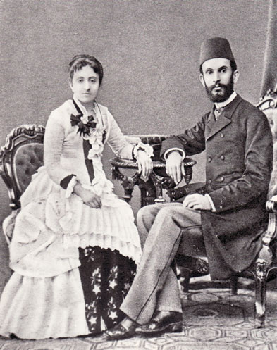
Sami bey Frashëri and his wife.
1889-1898
Sami bey Frashëri
Description of ChameriaAmong the most impressive publications of Albanian writer, Sami bey Frashëri (1850-1904), is a 4,830-page Ottoman Turkish dictionary entitled “Kamus al-a’lam” (Universal Dictionary of History and Geography), published in Istanbul in the years 1889-1898. This dictionary contains numerous entries on the towns and regions of Chameria or southern Epirus, now in northwestern Greece, as it was under the Ottoman Empire with a primarily Albanian population.
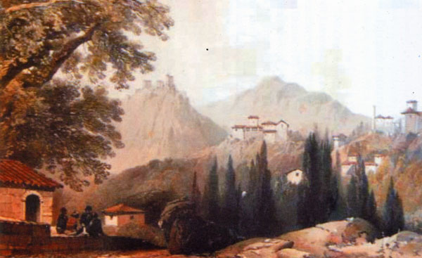
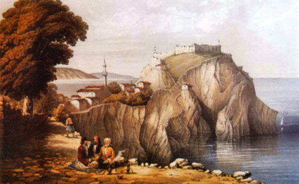
View of Paramythia
by George de la Poer Beresford, 1855.
Aydonat [Paramythia]
This town is also known as Paramythia. It is a kasaba and the capital of a kaza in the Vilayet and Sandjak of Janina that is situated in Chameria, the southeastern part of Albania. It is about 40 kilometres to the southwest of Janina, 18 kilometres to the east of the port of Morto, at the foot of a mountain on the left or eastern side of the river Vouvo [Kokytos]. It has a pleasant climate although it is at a high altitude. It is endowed with vineyards and gardens. It has 2,500 inhabitants, all of whom are Muslims and Albanians. The fortress is called Agios Donatos that, according to the inhabitants, is also called Paramythia. the name Aydonat that is in official use is derived from this Agios Donatos. Not far away are the ruins of the ancient town of Orija [Elea?]. It is a kasaba known for its trade and commerce and each year, in early September, a large fair is organized that lasts for five days. A very popular plant grows in some parts of this kasaba and kaza known as enfiye [basil?] of Janina, as does common tobacco.
The kaza with its kasaba encompasses 64 villages, of which 40 are situated to the north of the capital of the kaza, and 24 to the south. The nahiye of Souli whose population is known for its courage and the resistance it offered to Ali Pasha Tepelena, is situated to the southeast of this kaza. It is a mountainous region, but there are several plateaux and fair valleys. The land is farmed and produces a variety of cereals, tobacco etc. The population is about 16,000, of whom most are Muslims. Of these about half are Albanian. In this kaza, there are 22 mosques and prayer houses, 51 rushdiye [secondary schools], one medresa [religious school], two sibyenmektebe [elementary schools], three tanner shops and 13 bridges. One can travel the length of the kaza in 23 hours.
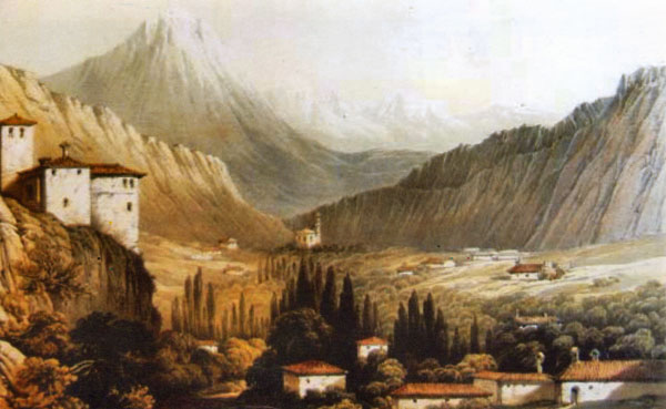
View of Filat
by George de la Poer Beresford, 1855.
Filat [Filiates]
This is a kasaba and the capital of a kaza in the territory of Albanian Chameria. It is situated in the Vilayet and Sandjak of Janina, 45 kilometres to the north of Janina and 15 kilometres to the northeast of the port of Sajada [Sagiada]. It has 5,000 inhabitants who are all Muslims, and one rushdiye.
The kaza of Filat borders on the Sandjak of Preveza to the south, on the Sandjak of Gjirokastra to the north, on the kaza of Janina to the east and on the coastline and the kasaba of Filat to the west. It includes 68 villages with 24,179 inhabitants. There are many orchards of olive and almond trees, fair farmland, and hills covered in various types of trees. The climate is mild which is why many people come here from higher reaches to spend the winter. Agricultural activity has been neglected and, as such, the land is not actually used for farming. In fact, many of the olive orchards have gone wild because there is no one to prune the trees. Most of the people of the kaza are Muslim and they are all Albanian. They are known for their courage, intelligence and wealth, but are not inclined towards farming and herding. In other words, they are not interested in such activities.
Janina [Ioannina]
This is a town and capital of the vilayet of the same name which is situated to the south of the Vilayet of Shkodra. It is 700 kilometres from Istanbul and 200 kilometres from Salonika [Thessalonika], and is situated on the western bank of the lake bearing the same name. Its geographical coordinates are 39˚47’ N and 18˚41’ E. It has 35,000 inhabitants, 30 mosques, six churches, two synagogues, three tekkes, many medresas, one library, one idadiye [secondary school], one iptidayye [elementary schools], several sibyenmektebe, one idadiye school specially for the Greeks called Zosimea, several sibyenmektebe, one mekteb [religious school] for women, and one rushdiye specially for the Vlachs. It also has one Greek home for old people, poor people and orphans, and one hospital. A hospital was recently built to cover the needs of the town. It has an attractive market, many inns and public baths. On the headland sticking out into the lake, there is a fortress from the time of Ali Pasha Tepelena, around which are many military buildings to train the army. Near town are vineyards and fertile land. There are tanners, silversmiths, tinkers and many merchants.
[The town] was constructed by a prince called Yani who appeared here when the Byzantine Empire took over. It surrendered peacefully at the time of the late Yildirim Sultan Bayazid Khan, but later managed to rebel and was retaken definitively at the time of His Majesty, Sultan Murat Khan II, in 835 AH [1431 AD]. Independent once more, it was embellished and flourished at the time of Ali Pasha Tepelena, with more and more inhabitants flocking to it.
The kaza of Janina extends through the middle of the sandjak and vilayet of the same name. Together with the two nahiye of Zagora and Korondos, it encompasses 223 villages with 87,256 inhabitants. The land is used variously; there is farmland, pastureland and forests. Most of the inhabitants are Christians. There are Greeks and Vlachs.
Janina, Vilayet of
The Vilayet of Janina is one of the vilayets of Roumelia [European Turkey]. It includes most of the south, i.e. the half of Toskeria that was formerly called Epirus. It is situated between 38˚56’ and 41˚ N and 17˚ and 19˚ E. It has a surface area of 18,200 square kilometres and 650,000 inhabitants. It borders to the north on the Vilayet of Shkodra, to the northeast on the Vilayet of Monastir, and to the southeast on Greece. To the south, it borders on the Gulf of Arta, to the southwest on the Greek [Ionian] Sea and to the west on the Adriatic Sea. Land usage is varied.
The highest mountain range in eastern Roumelia is the Pindus that stretches from north to south. To the west of it is Mount Gramos. Near Berat there is is an isolated mountain called Tomor. There are many other mountains within the borders of the vilayet, such as Trebeshina, Nemërçka, Lungara, Uliçka, Souli, etc. In these mountain areas there are few wide plains and valleys. There is a beautiful range of hills along the coastline to the south, and to the northwest there is a expansive plain called Myzeqeja. All the rivers of this vilayet empty into the Adriatic and Greek Seas.
The largest rivers are the Vjosa [Aoos] and Seman. The former takes its source in the Pindus mountains in the southeast of the vilayet and flows in a northwesterly direction, emptying into the Adriatic Sea north of Vlora. As to the Seman river, it takes over from Devoll and Berat rivers, the latter also known as the Osum. Both of these take their sources from Mount Gramos. It flows in a northwesterly direction and joins the Dishnica in Myzeqeja, then turning southwest and to the left of the Vjosa flows into the above-mentioned sea. Smaller rivers include the Vouvo, that is also called Mavropotamo, and the Arta [Arachthos], that constitutes the border with Greece and flows into the Gulf of Arta. Following these are the Lurus [Louros], that also flows into the Greek Sea and the Pavlle, Bistrica and Kalamas rivers that also flow into this body of water.
Some of the rivers flow into the Vjosa are of a considerable size. The largest of them is the Lengarica on the right side and the Drino on the left. The largest lake is that of Janina, and following it come that of the plain of Myzeqeja, Tërbuf and Lurus. Along the coastline, there are swampy lagoons such as Karavasta in Myzeqeja, Souli and Vlora.
In the winter, the mountains are covered in snow. Although it is very cold in higher reaches, the valleys and the coastal area have a mild, warm climate. It rarely snows there in the winter and the soil is fertile. The main crop is maize, followed by wheat, barley, rye, oats and other cereals, rice, tobacco, and some cotton and flax, etc. After covering domestic needs, much of his produce is exported. Near the coast, they grow olives and in some places wild olives. Around Preveza, there are many lemon, orange and mandarin trees. And the vineyards produce much fruit, which is mostly for export. There are various kinds of trees, in particular many mulberries, and in some place they make silk. Although there are not many forests, they suffice to meet local needs and there is enough left over for firewood and for construction. The trees are primarily Scotch pines and firs, etc. There is much pastureland, both in summer and in winter, and the inhabitants raise many goats and sheep. There are not many cows, and these are mostly of a small race. The horses that are raised on the plain of Myzeqeja are also small in build.
The lake of Janina produces various types of fish. Particularly well known are the eels. They also fish in Preveza and Butrint and have good-quality roe. The mines have not yet been sufficiently investigated, but in many places there are sulphuric waters with various minerals that are used to cure a variety of illnesses. They are still in an untouched, natural state.
As to the population, two-thirds of the people are Muslims and one-third Christians. Aside from this, all the Muslims are Albanians as are most of the Christians. Only in the Sandjak of Janina are there also Vlach and Greek villagers. The Albanian Christians have expressed their desire to read and write in their own language.
Local industry is based on wool production for jerkins, bed and floor covers, and socks, but cotton and silk are also used to make fine clothes, Albanian costumes and cord etc. In Parga, they produce a type of grey soap that is very fragrant. In Konica [Konitza], there is an excellent type of cheese called arnavud peynir [Albanian cheese] and other dairy products. Many articles, from foodstuffs to wool and hides, are exported to Trieste, Italy, Greece and elsewhere, and more is exported than imported. Aside from taxes and other duties, the Vilayet has annual revenues of 300,000 pounds. Expenditures amount to about 80,000 pounds.
The Vilayet of Janina consists of four sandjaks, 19 kaza, 10 nahiye and 1,597 villages, as follows:
Sandjak
Kaza
Nahiye
No. of villages
Janina
Janina
Leskovik
Konica
Maçva
Aydonat
FilatZagora
Korondos223
49
34
3
62
68Preveza
Preveza
Lurus
Margëlliç
Çermenika
Parga
Fanar36
6871
Gjirokastra
Gjirokastra
Delvina
Pogoni
Përmet
Tepelena
Kurvelesh
Saranda
Frashër
Himara
64
92
38
99
63
22Berat
Berat
Vlora
Lushnja
GusteniçkaMallakastra
Fier
Skrapar218
71
215
101The Sandjak of Janina is the centre of the vilayet of the same name. It borders to the southeast on Greece, to the northeast on the Vilayet of Monastir, to the northwest on the Sandjak of Gjirokastra, to the west on the Greek Sea, and to the south on the Sandjak of Preveza.
Konica [Konitza]
This is a kasaba and the capital of a kaza in the Vilayet and Sandjak of Janina, 45 kilometres to the northwest of Janina. It extends along the side of a plain at the foot of a mountain that rises above the Vjosa [Aoos] river, and has 5,500 inhabitants. There is much pastureland in the vicinity and, because there are many sheep, they produce a well-known Albanian cheese. The population is known for its intelligence and wit.
The kaza of Konica is surrounded by the kaza of Janina to the south, the Sandjak of Gjirokastra to the west, the kaza of Leskovik to the north and the Vilayet of Monastir to the east. It has 34 villages with about 25,000 inhabitants, half of whom are Muslim Albanians and the other half Christian Albanians and Vlachs. The terrain is mountainous and there is little farmland, but there is an abundance of pastureland so there are many sheep, goats and other animals. On the plain of Konica and in the valley of the Vjosa there are many mulberry orchards on which the silkworms feed, producing much silk. In the villages, the children make woollen socks and undershirts, woollen bed and floor covers, and other things. The Vjosa river divides the kaza and takes on the waters of the Vojdomati [Voidomatis] and the Sarandopori [Sarandaporos]. In this kaza, there are sulphuric baths with very hot water that has proven itself useful in many concrete cases. Once a year, there is a fair called pazarpol, to which are brought many animals and many good made by the women, etc.
Lurus [Louros]
This is a river in the southern part of Albania that is situated to the south of Janina. It takes its source from Mount Uliçka, flows southwards and, upon entering the plain of Arta, it turns southwestwards and flows across the aforementioned plain, forming several marshes on its way, and empties into the Gulf of Arta, between Preveza and Salahora.
Lurus, also called Filipiada, is a kasaba and the capital of a kaza in the Vilayet of Janina and in the Sandjak of Preveza, 30 kilometres north of Preveza. It is situated on a plain, beside a river that flows into a river of the same name. It has 2,000 inhabitants, one mosque, several inns and some shops. When Arta was given to Greece, this kasaba was populated primarily by refugees from Arta. It has an arduous climate.
The kaza of Lurus makes up the eastern part of the Sandjak of Preveza. To the north it borders on the Sandjak of Janina and to the east on Greece. Together with the nahiye of Çemernika, it has 68 villages and 20,000 inhabitants. The land is very fertile and is used for farming. There is much pastureland, enough for the sheep to spend the winter here. It exports many animals, maize and other articles.
Margëlliç [Margariti]
This is a kasaba and the capital of a kaza in the Sandjak of Preveza. It is situated about ten kilometres from the sea and has 3,000 inhabitants, all of them Muslim Albanians.
The kaza, together with the nahiye of Parga and Fanar, encompass 71 villages with about 25,000 inhabitants. All of the population is Albanian, of whom most are Muslims. They are known for their courage and bravery. The soil is fertile and produces crops such as rice and olives, etc.
Since it is near the sea, it has a mild climate, so there is good pastureland here for the sheep in the winter. Aside from [the port of] Parga, there are a few small rivers that are navigable with small boats and skiffs.
View of Parga
by George de la Poer Beresford, 1855.
Parga
This is a kasaba and the capital of a nahiye on the southern coast of Albania, in the Vilayet of Janina, Sandjak of Preveza and the kaza of Margëlliç. It is situated 45 kilometres to the northwest of Preveza and 55 kilometres to the southwest of Janina. It has 5,000 inhabitants, one mosque, one fortress that rises on a cliff overlooking the sea, surrounded by orange, lemon and olive orchards. Its primary exports are oranges, lemons and olives. This kasaba also produces a type of grey-coloured soap. It has a splendidly mild climate that is very conducive to healing respiratory diseases. Swimming in the sea is also very helpful. Although ships cannot dock here, it is the chief port of Chameria, with sailing ships coming and going to Corfu and Trieste and conducting much trade. This kasaba was in the hands of the English for a long time. When Ali Pasha Tepelena bought the kasaba from the English, the population emigrated and it became the personal çiflik of Ali Pasha. After his execution, his assets were handed over to the government and then sold by Rifat Pasha, a finance inspector. Nowadays, it is in private hands. The people here are Muslim Albanians with some Christian Albanians and Greeks.
The nahiye of Parga includes the central part of the plain of Chameria and belongs to the kaza of Margëlliç. It consists of the kasaba itself and three surrounding villages. Together with other villages, it forms the kaza itself.
Preveza
This is a kasaba in southern Albania, to the west of Arta. It is situated in the Vilayet of Janina and is a sandjak of the same name and a centre of Chameria. It is 92 kilometres to the southwest of Janina and has the geographical coordinates: 38˚57’5” N and 18˚24’57” E. It has 8,000 inhabitants. There are many orchards with oranges, lemons and olives. It is protected from the sea by four fortresses and two positions equipped with cannons, and from the land by a canal built by Ali Pasha Tepelena. In the kasaba there are two mosques, one of which constructed by the aforementioned Ali Pasha and the other one by Ahmet Agadino, as well as two tekkes and a number of mausoleums. It has one rushdiye [secondary school], several iptidayye [elementary schools], two schools especially for the Greeks, one for boys and the other for girls, one steam mill, two tanner shops, and a number of soap makers, etc. Good-quality textiles of cotton and silk are made in the kasaba, as are socks, etc. The harbour is very profitable and gains much revenue from trade with Trieste, Corfu and a few ports in Greece and Italy. To the north, there was once a large harbour called ‘vathi’ which means deep. This was the harbour of the ancient town of Nicopolis. The word Preveza is taken from the name of the ancient town founded by the famed Pyrrhus. It was constructed by Octavian, whereas the ruins to be found one hour to the north of Preveza are those of Nicopolis, destroyed in a Bulgarian-Serbian attack. The Republic of Venice constructed present-day Preveza and the town was under its rule for quite some time. Later, with the seven islands [Heptanesos], it fell into the hands of the French and in 1798, Ali Pasha Tepelena took it in fighting with the French. Since that time, it has been under the sway of the Ottoman authorities. Its position is promising from a commercial and military point of view.
Preveza, Sandjak of
This is the smallest of the sandjaks in the Vilayet of Janina. It is situated in the southern corner of Albania and forms the southern half of Chameria. It borders to the north on the Sandjak of Janina, to the east on Greece, to the south on Arta and the channel of Preveza, and to the west and southwest on the Greek Sea. Most of the land consists of hills covered in orchards of lemon and orange trees, and of beautiful pastureland. Although the soil is very fertile, the presence of a number of swamps and marshes poisons the climate, such that most of the land is not used for farming. It is only used as pastureland for the animals in the winter. The Arta [Arachthos] river flows to the east of the sandjak and forms the border with Greece. There are two other rivers in this district. One of them is in the Sandjak of Janina and is joined by the waters flowing down from the Uliçka mountains to form the Lurus river. It makes the plains between the Gulf of Arta and Preveza very swampy, and then flows into the bay. The other river is the Ferar that flows through the kaza of Margëlliq. It takes its source in the Souli mountains, flows westwards, joins the Vouvo [Kokytos] river coming from the north, and flows into the Greek Sea. This river which in ancient Greek legends was known as the gates of hell, is called the Acheron.
The population is about 55,000, most of whome are Muslims. There are also Christians and a few Jews. The Muslim population is all Albanian, as are most of the Christians. Only near the Greek border in the kaza of Preveza are there Greek Christians. In this district there are 179 villages, 48 mosques and prayer houses, 2 medresas, 30 mekteb [religious schools], 220 churches and monasteries, 450 shops, 50 mills, etc. Of agricultural produce, mention may be made of various cereals. Primarily they grow oranges, lemons, pomegranates, olives and other fruit. They export large amounts of olive oil, and many animals. All the herders who spend their summers in the mountains of the Sandjak of Janina, come down with their sheep to the pastures of the Sandjak of Preveza. The climate is mild and there is rarely snow.
The sandjak is divided as follows:
Kaza
Nahiye
No. of villages
Preveza
Lurus
Margëlliç----
Xhemernik
Parga38
68
73The kaza of Preveza is situated in the southern part of the vilayet. To the east it borders on Lurus and to the north on the kaza of Margëlliç. The territory of the kaza is extensive, but there are few inhabitants. It consisted of only 38 villages and, including the capital, it has 13,000 inhabitants. In the countryside, most of the people are Albanian Christians. With its pastureland and olive orchards, this kaza is the wealthiest one in the sandjak.
[Extracts from: Samy-Bey Fraschery, Kamus al-a’lam (Istanbul: Mihran 1889-1898 [1306-1316 A.H.]). Republished in Albanian as Sami Frashëri, Vepra 7 (Prishtina: Rilindja 1984). Translated from the Albanian by Robert Elsie.]
TOP
